SharedGeo has created an open source solution to a longstanding cartographic problem by creating a free web service to generate a magnetic declination diagram.
In cartography, a declination diagram is used to provide a graphic representation of the variations between true north, grid north, and magnetic north on a map. True north is the center of the earth’s rotation. Grid north is the orientation of the map projection coordinate system. Magnetic north is the point at which the earth’s magnetic field points vertically downward in the northern hemisphere; a compass north needle points to this location. Magnetic north changes over time due to changes in the magnetic field of the core of the Earth. A declination helps a map user make adjustments in bearings when using a compass and a map for navigation.
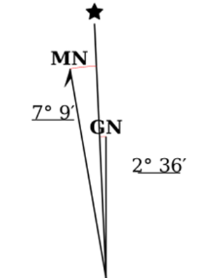
Although many utilities exist for calculating the declination angles, creating a suitable declination diagram manually can be tedious, especially when creating a map series that spans a large area. This is because the declination diagram will be unique to each map, representing the differences between the three norths at the center of the map at a specific point in time. However, the SharedGeo web service creates a declination diagram automatically, returning a scalable image that can be inserted into a map layout using mapping software. It uses the NOAA World Magnetic Model.
SharedGeo is a Minnesota nonprofit dedicated to helping government, nonprofit, education, and corporate entities use mapping technologies and share geographic data for the public good.